Overview
California Indian Geographies: Reading Maps and Mapping Space
Author: Stephanie Lumsden, PhD (Hupa)
Lesson partner: Rebecca Lowry, Humboldt County Office of Education
Grades: 9-11
Suggested Amount of Time: 60 minutes
Curriculum Themes
- History
- Cultural Strengths
- Relationship to Place
Learning Goals
Students will be able to analyze the historical and cultural significance of mapping through videos and in-class discussions.
Students will be able to identify 3 important California Indian sites and give examples of how California Indians map historical and ongoing Indigenous presence.
Students will be able to produce a personal map of California that reflects their relationship to place using what they learned in the lesson.
Unit Overview
This lesson introduces students to the important concepts of Indigenous geographies and mapping in California. The lesson covers the historical and political context of mapping and uncovers its relationship to U.S. invasion and ongoing occupation of California Indian homelands. The lesson covers 4 key terms and analyzes 3 significant California Indian places in order to demonstrate mapping to students beyond a one dimensional understanding of what maps are. The lesson includes videos and a creative in-class activity where students will get the chance to draw their own map of California.
Teacher Background
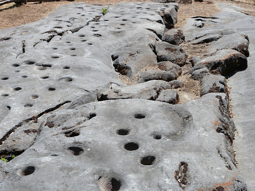
For California Indians and all Native Americans, relationships to homelands are demonstrated through story, rock art, material daily practices, and ceremony. One way to study Indigenous peoples’ relationship to their homelands is through geography. Indigenous peoples have always mapped spaces of social and spiritual significance in ways that may seem surprising to those who only engage with contemporary road maps or gps. Indigenous peoples such as the Miwok, Modoc, and Yurok mapped their relationships with their homelands through grinding stones, petroglyphs and place names. Indigenous mapping of homelands did not rely on exclusionary borders; homelands constituted by relations with other nations and more-than-human beings. Mapping has long been a tool of conquest for imperial and colonial invasion which sought to displace/erase Indigenous relationships to homelands. For example, Sue-Meg was renamed “Patrick’s Point” by U.S. settlers as a way to erase Yurok presence and persistence on their homelands. Importantly, reconstituting California Indian homelands into the territorial sovereignty of the U.S. was accomplished in part by mapping. However, California Indian geographies and mapping practices have endured occupation. Sites such as Chaw’se, Lava Beds, and Sue-Meg demonstrate California Indian peoples embodied resistance and persisting Indigenous geographies. California Indian mapping practices mark Indigenous places and assert ongoing presence in spite of U.S. occupation.
Interactive Slides
About the Interactive Slides
A key component of this curriculum includes interactive slides and a lesson script/facilitation support. These materials are designed to support ease of implementation and help guide lesson delivery.
The interactive slides are animated to gradually reveal content and may include links to videos and audio playback buttons for Tribal language integration, songs, or slide facilitation.
In addition to the downloadable lesson and student handouts, this lesson comprised of 60 minutes includes interactive slides and lesson script/ facilitation support.
Slides: California Indian Geographies: Reading Maps and Mapping Space
Lesson Script/ Facilitation Support
*To ensure full accessibility, we recommend making a copy of the instructional material(s).
Instructions:
To use the slides effectively:
- Project the slides in "Slideshow Mode" to activate animations. Written content will appear with each click.

- Set speaker volume before beginning the lesson to ensure all students can hear audio content.
- Play audio by clicking the audio playback icons one at a time. There may be a brief pause while the audio loads.
- Hovering over an audio playback icon will reveal a playback bar that allows you to play, pause, adjust speed, or fast-forward the audio.

- Note: You do not need to use the playback bar unless you wish to adjust playback. Simply clicking the icon will play the audio.